


Now Reading: 123-Year Rainfall Data Highlights August Disaster Risks in State
-
01
123-Year Rainfall Data Highlights August Disaster Risks in State
Swift Summary
- Flood impact: This week marks the seventh anniversary of Kerala’s 2018 mega flood, which claimed nearly 500 lives. Rainfall patterns in August raise concerns about potential disasters based on historical data.
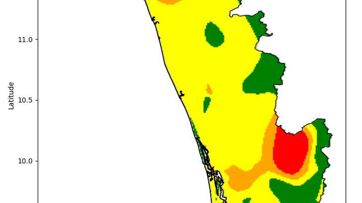
- Rain Data Analysis: A rainfall map developed by P.S. Biju, IMD senior scientist, uses machine learning adn GIS techniques to review data from 110 weather stations (1901-2023). It highlights areas in north Kerala, Idukki, and Pathanamthitta as vulnerable to heavy rainfall in August.
- Map Color Codes Explained:
– Red: Minimum three heavy rainfall events recorded in August.
– Orange: Two intense rainfall events.- Yellow: At least one heavy event recorded.
– Green: No intense events recorded during many years in August.
- Historical Trends: While June and july are usually wetter months for Kerala monsoon:
– In August 2018, record precipitation (820.9 mm) flooded large parts of south-central Kerala following excess rains earlier that season.
– In contrast, low cumulative rain prior to August reduced disaster severity during the significant floods of August 2019 (950.5 mm).
– Other major floods (1924 “great flood” and a similar event in July 1961) occurred during different months but with high precipitation levels over a short timeframe.
- This year’s forecast suggests below-normal rainfall for august with subdued patterns observed so far.
Indian Opinion Analysis
The analysis of IMD’s long-term rain records underscores the importance of mapping precipitation vulnerabilities across districts like Idukki and Pathanamthitta. The strategic use of machine learning and GIS techniques helps identify trends crucial for disaster preparedness.
While historical insights show variable month-on-month trends leading to flooding disasters-like those seen prominently in an oversaturated monsoon season during the catastrophic floods of both modern times (2018/19) and older ones (1924)-the current subdued pattern offers some respite this year. However,given recurring vulnerabilities associated with dense terrains exposed to extreme bursts even within short intervals,tailored mitigation strategies must accompany ongoing meteorological data analysis.
kerala’s context exhibits how early warning systems can be strengthened through precise localization enabled by tools like these maps while also pushing awareness among at-risk communities regarding structural resilience measures against unpredictable yet recurring climatic extremes.
Read More: Link
—
Image Courtesy:
!Rainfall Map


Related Posts
Stay Informed With the Latest & Most Important News
Previous Post
Next Post


Advertisement


