

Now Reading: Charting Earth’s Magnetic Field
-
01
Charting Earth’s Magnetic Field
Fast Summary
- Magnetism was first discovered around 1000 B.C. by a shepherd named Magnes on Mount Ida (modern-day Turkey), uncovering magnetite, a magnetic oxide of iron.
- The Chinese invented the first magnetic compass before 100 A.D., initially used for feng shui adn later adapted for navigation in the 1200s.
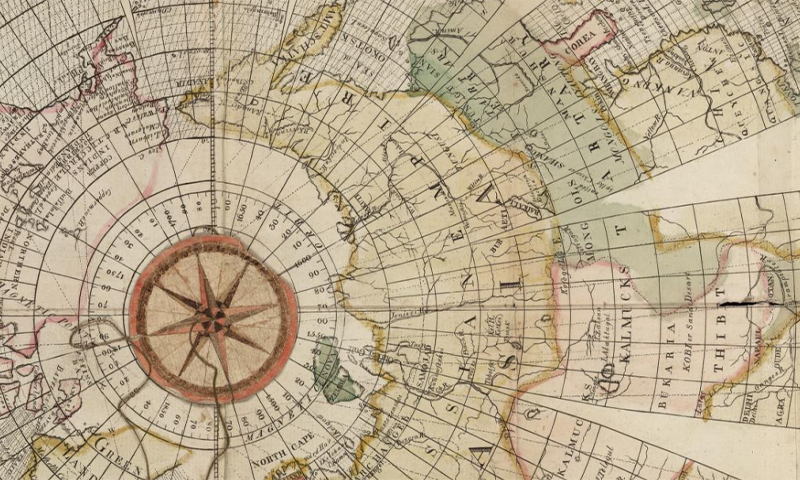
- Scholars identified magnetic declination-the angle between true north and magnetic north-prompting map-making efforts to understand Earth’s magnetism.
- Flemish cartographer Gerhard Mercator depicted polar magnetism sources such as “very high black cliff” in his Arctic maps in the 1500s based on early speculations.
- Edmond Halley mapped magnetic declination using isolines in his pioneering chart from 1701 after an expedition funded by King William III.
- In 1831, James Clark Ross pinpointed magnetic north at Boothia Felix (Canadian territory Nunavut), while Ernest Shackleton mapped South Magnetic Pole in 1909 during expeditions.
- Modern science attributes Earth’s magnetic field to molten iron flux within its core but much remains unknown about its variations over time.
Indian Opinion Analysis
Earth’s magnetism has profoundly influenced human navigation, science, and geography. The advancement of tools like compasses enabled global exploration, facilitating cultural exchanges that shaped history-including India’s own interactions with explorers and traders across centuries. India could benefit from studying these principles further; understanding geomagnetic phenomena may enhance disaster preparedness or assist scientific endeavors such as space exploration initiatives.
Preserving historical maps and methodologies builds deeper recognition for earlier contributions made globally in deciphering Earth’s complexities-a lesson pertinent for indian researchers prioritizing interdisciplinary advancements.
Read More: Mapping Earth’s Magnetism


Related Posts
Stay Informed With the Latest & Most Important News
Previous Post
Next Post


Advertisement


