


Now Reading: New Satellite Network to Monitor Wildfires Every 20 Minutes
-
01
New Satellite Network to Monitor Wildfires Every 20 Minutes
Swift Summary
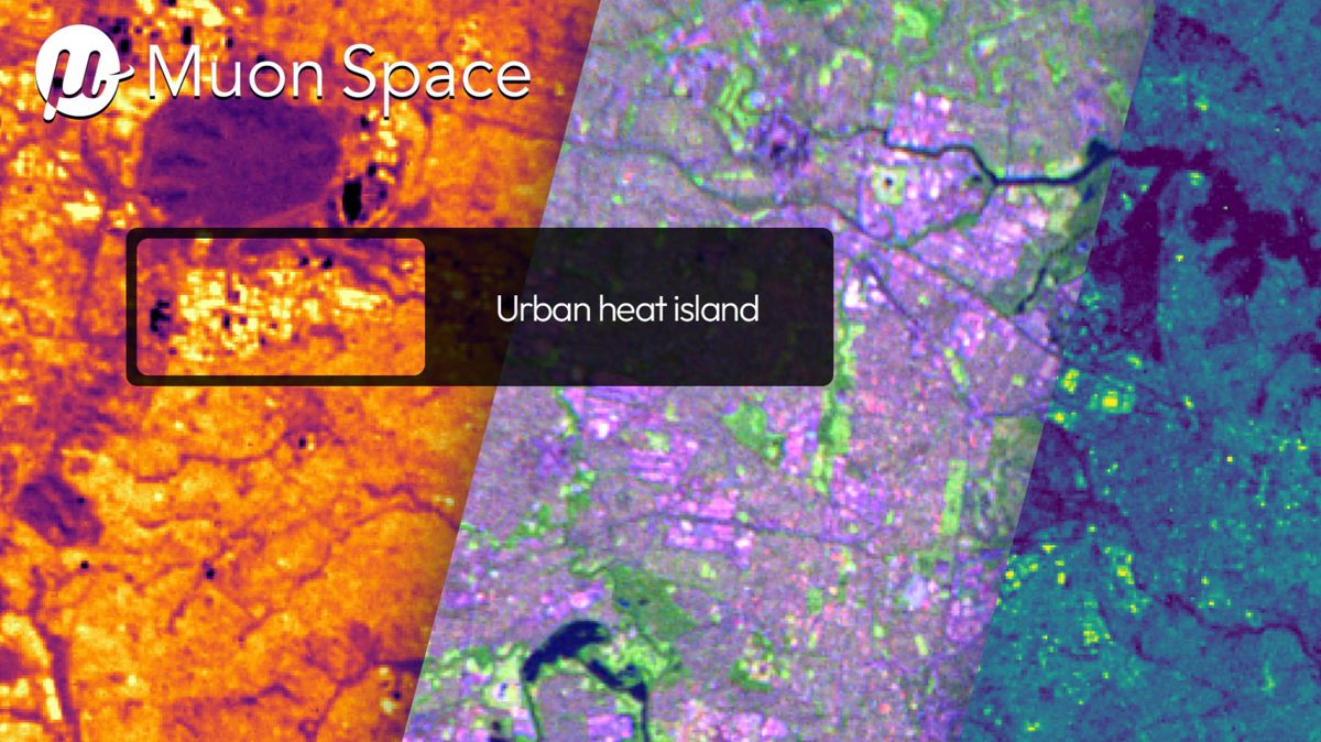
- Muon Space’s FireSat protoflight satellite released its first infrared images three months after launch on March 14, 2023.
- FireSat is the initial satellite in a proposed constellation of over 50 satellites designed to monitor wildfires globally.
- Using multi-band infrared sensors, the satellite scans Earth’s landscape for heat signatures indicative of fires and minimizes false positives by utilizing six different IR channels.
- The constellation aims to scan every point on Earth every 20 minutes, with frequent monitoring of wildfire-prone areas.
- Initial scans from FireSat include rural and urban areas like Sydney’s airport runway, Hawaii’s Kīlauea volcano lava fountains, and Libya’s Sarir oil field complex detecting gas flares.
- The full constellation is expected to be operational by 2030, with data supporting policymakers and first responders through collaboration with Earth Fire Alliance.
Indian Opinion Analysis
FireSat demonstrates important advancements in space-based wildfire detection systems that feature high-resolution infrared imaging technology.With plans to cover global landscapes comprehensively every 20 minutes by its completion in 2030, this innovation addresses critical climate-related challenges.For India-frequently enough vulnerable to forest fires due to dry seasons-such technologies could aid early intervention strategies reducing economic losses and ecological damage. If leveraged effectively through collaborative research or integration into current disaster management programs like NDMA (National Disaster Management Authority), India’s fire-monitoring capabilities could become far more precise.Additionally, these satellites may also offer opportunities for broader applications such as agricultural monitoring or industrial safety measures given their capacity for detecting diverse heat anomalies.


Related Posts


Stay Informed With the Latest & Most Important News
Previous Post
Next Post


Advertisement


