



















Now Reading: Brahmaputra 10 metres from breaching Biswanath embankment
-
01
Brahmaputra 10 metres from breaching Biswanath embankment


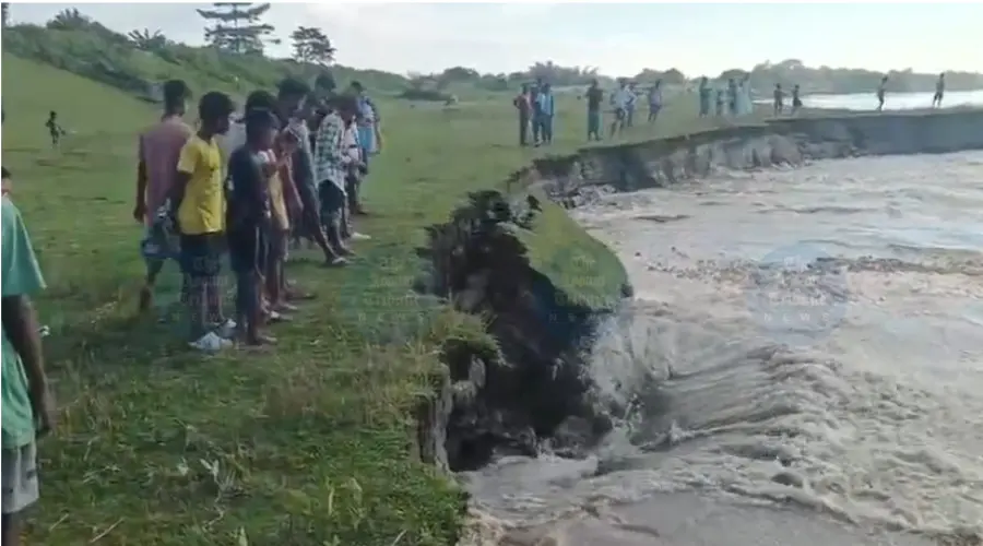
The Brahmaputra is now just 10 metres from breaching the Biswanath Ghat-Panpur embankment at Solmari village in Assam. Strong currents swallowed about 200 metres of land since Tuesday morning, a local resident…
The Brahmaputra is now just 10 metres from breaching the Biswanath Ghat-Panpur embankment at Solmari village in Assam. Strong currents swallowed about 200 metres of land since Tuesday morning, a local resident said, warning that another 10 to 12 metres of erosion could wash away the vital stretch. The embankment protects villages in Biswanath Chariali, Sootea and Jamugurihat, and residents fear a breach would put hundreds of families and properties at risk.
Locals alleged that negligence in anti-erosion works over the years had worsened the crisis, with their concerns repeatedly ignored. The administration has been urged to deploy mega geo-bags immediately. The threat comes as a satellite study by the North Eastern Space Applications Centre found that more than 30,000 hectares of agricultural land across Assam were lost to river erosion between 2016 and 2024, with Barpeta, Dhubri, Nalbari, Morigaon and Goalpara as major hotspots.
Indian Opinion Analysis
Riverbank erosion is not a new crisis in Assam but a chronic cycle that state and central governments have fought with embankments and geo-bags for decades. The Brahmaputra Board, established in 1982 to plan integrated flood management, has built hundreds of kilometres of embankments, yet satellite data from the North Eastern Space Applications Centre shows over 30,000 hectares of farmland lost to erosion in just eight years. In Biswanath, the embankment between Ghat and Panpur protects the Biswanath Chariali-Sootea-Jamugurihat cluster, an area home to tens of thousands. The next 10 to 12 metres of erosion will decide whether the administration's deployment of geo-bags arrives in time, making the next 48 hours the real measure of whether past promises hold against this season's current.
Source: assamtribune.com
This brief was synthesised by AI from the source linked above.